In the previous chapter, we learned about the water cycle and general circulation, the 3D movement of air in the atmosphere. Let’s look at how general circulation can affect rain and storms in the tropics - and what climate change might mean for both.
How does wind move around the tropics?
Wind is important to the water cycle because it redistributes vapour around the planet , affecting where and how it rains. Evaporation from the ocean forms clouds that can be moved by wind to rain over land :
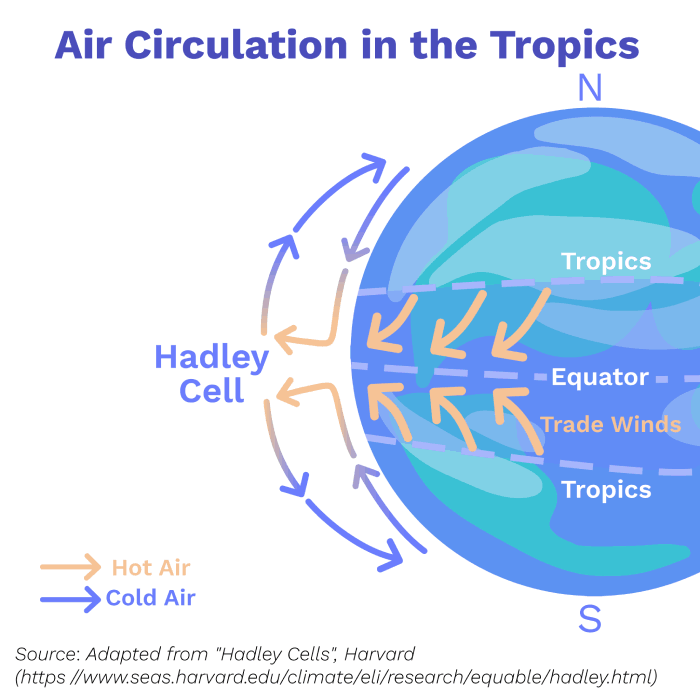
As we learnt in the Water Cycle chapter, the tropics receive more heat energy from the sun, so air in this region is warmer than in the rest of the atmosphere . This makes it less dense than colder air .
The density of a gas refers to how many molecules of it are present in a given volume. Adding energy to a gas causes it to expand and become less dense: because its molecules have more energy to move around, they become more spread out . Differences in density between air masses create wind currents in several ways:
Wind Circulation at the Tropics
Hot air rises as colder, denser air from the surroundings pushes it upwards and out of the way. This property is called buoyancy.
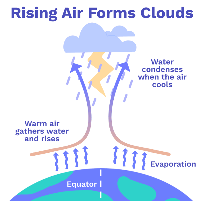
Hot air at the equator creates a current of rising wind. As the air rises, it experiences lower pressure, because there is less air pushing down on top of it . The temperature, pressure, and volume of a gas all affect each other : like higher temperatures, lower pressure allows the air to expand and increase its volume.
Expanding air pushes away the air surrounding it . This requires energy, which comes from the heat of the gas . As a result, expansion causes the rising air to cool . As it cools, the water vapour inside it becomes liquid, forming clouds .
Rising wind also loses its buoyancy because, as it rises, the density of the surrounding air decreases . Eventually, it is unable to rise any further. At this point, the wind is pushed sideways and splits into two separate currents, which travel towards opposite poles .
As these currents travel towards the poles, they sink back towards the surface of the planet. As they sink, they experience increasing pressure, which causes them to warm again . Having left their water behind as clouds, this warm, dry air creates deserts like the Sahara and the Kalahari .
Rising Air forms Clouds
At the surface of the planet, denser air travels back towards the equator . This completes the circulation of air around the tropics, known as the Hadley Cell.
These westward winds at the tropics are known as the Trade Winds. They redistribute water vapour from the equator, and their strength influences how much it rains over land .
The Monsoon
To see how wind circulation can affect rain patterns, let’s explore the seasonal heavy rains found in tropical regions known as Monsoons.
The Monsoon of South Asia happens between June and September every year.
During this season, the land warms more than the ocean around it because water has a high heat capacity . This temperature difference creates a density difference which drives a large movement of air from over the ocean onto land .
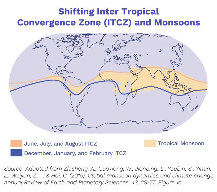
This movement of air causes intense rains in the tropics because of the Hadley Cell. Remember that warm air near the equator rises and forms clouds? The region in which this happens is called the Intertropical Convergence Zone (ITCZ) , and it is associated with heavy rain because of all the clouds that form along it .
In spring, the wind currents flowing northwards towards South and Southeast Asia carry moist air and shift the ITCZ northwards with them. The ITCZ brings its storms with it, creating the intense rains of the Monsoon. These monsoons contribute 80% of the year’s rainfall within South Asia .
Shifting ITCZ and the Monsoon
Because of the intensification of the water cycle, and changes to general circulation, it’s predicted that monsoons will impact a larger area, and rainfall will decrease over the Indian Ocean and increase over India.
Climate models predict that by 2100 the rain associated with the Indian Monsoon will increase by 5% if we restrict warming to 2°C above pre-industrial levels, and by 10% if we allow it to reach 4°C !
Tropical Cyclones
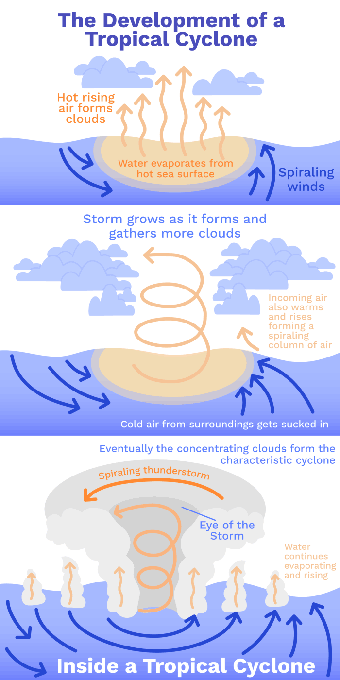
Tropical cyclones are large storms that form along tropical oceans. They are thought to be the most violent storms on the planet .
Several conditions in the atmosphere have to occur at the same time for them to form. If an area of the ocean becomes particularly warm (more than 27°C), the hot air creates a rising current that is stronger than normal. This must coincide with wind bringing in more water vapour to this area, providing more water to fuel the growth of the storm above .
A cyclone of large clouds forms when winds are deflected to the west and begin to spiral as a result of the rotation of the Earth. As with the Trade Winds, this concentrates the incoming water vapour . As it travels over the ocean, the storm gathers water and continues to grow .
Storms Concentrate Water from Far Away
The storm grows through different stages. It starts as a cluster of thunderstorm clouds. Eventually it becomes a full scale tropical cyclone, where the rising current of air in the middle is so strong that the ocean beneath it forms a large bulge of water. This is responsible for the rise in sea level that can cause flooding where the storm reaches land, known as a storm surge.
How does climate change come into play here?
Global warming provides the atmosphere with more water vapour, giving storms more water to create heavier rainfall .
Models predict that by the end of the century, a warming of 2°C above pre-industrial levels could increase the average intensity of tropical cyclones by 1-10% .
Conclusions
We now know more about air circulation in the tropics, heavy rains/storms and how climate change is likely to affect them. But this is still only a glance at the complex system that is our atmosphere! So next time it rains on your “sunny day”, spare a thought for your poor weather forecaster!